
NEWS ARCHIVE
01/02/2013
Emergency Siren Mapping for Champaign County
Working under an arrangement with the Champaign County Emergency Management Agency (EMA), Ploughman Analytics has created a series of maps with the locations of the county’s emergency siren assets plotted using ESRI’s ArcGIS mapping software. In addition to the locations of the sirens, the map includes 0.25 mile and 0.5 mile rings around each siren along with a population dot-density layer derived from U.S. Census Block data. Blending Census and siren data allows visualization of the numbers of county residents and their proximity to siren(s). Click on the thumbnail for a more detailed view.
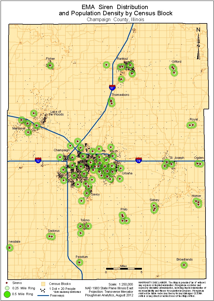
Ploughman relied in part on high-resoulution aerial photography for identification of siren locations and latitude/longitude coordinates. This map of emergency siren assets allows decision makers at the Champaign County EMA to communicate where siren coverage is strongest and those areas that potentially have gaps. The low-cost methods utilized by Ploughman are an expression of our resourcefulness and our desire to provide high-quality results for the public good.
Ploughman Analytics is proud to work with local, state, and federal government agencies along with private sector businesses to make life in Champaign County safer for everyone and was pleased to perform this work for the Champaign County EMA pro bono.
Map Disclaimer: The map(s) created by Ploughman Analytics utilized data considered to be accurate; however, a degree of error is inherent in all maps. The map(s) is distributed "AS-IS" without warranties of any kind, expressed or implied, including but not limited to warranties of suitability to a particular purpose or use. The dot-density layer contains dots that are randomly distributed and do not reflect actual residences. No representation of the operational status of any sirens is made.
03/19/2012
Location Intelligence workshop at ILGISA Spring 2012
Ploughman presented a workshop on location intelligence as part of the Illinois GIS Association Spring 2012 conference. The goal of the workshop was to help businesses understand how a combination of business intelligence (BI) and geographic information systems (GIS) can inform decision making and save money. The event was a great success and we recieved plenty of positive feedback from the attendees - many thanks to the organizers of ILGISA 2012 for making this event possible.
If you attended the workshop and would like to share lessons learned, or you are simply interested in reaching out to us for more information on this topic, please contact us at info@ploughman-analytics.com
03/09/2012
Ploughman interview with One on One TV program
President Charles Linville sits down with Alex Ruggieri to discuss Ploughman Analytics on this episode of One on One. In this interview you can learn more about some of our body of work and our goals as a growing company.
Watch the Interview
12/11/2011
Ploughman featured on Central Illinois Business
President Charles Linville sits down with Alex Ruggieri to discuss Ploughman Analytics on this episode of Central Illinois Business. In this interview you can learn more about some of our body of work and our goals as a growing company.
Hear the Interview
Ploughman Analytics, Inc.
3309 Cypress Creek Road
Champaign, IL 61822
(217) 693-4000
